Map Data: 1960 Security – Upland District
I had a nice skype interview with a grad seminar at my alma mater yesterday, UW in Seattle, and one student very rightly asked me when I was going to upload the map data I’d promised in my book to readers. The answer, friends, is NOW. I am renting some space on this server, 100GB, and I intend to USE IT! I’ll start with an archival map from the Vietnamese National Archives in HCM City from the records of the Cabinet of the First Republic of Vietnam (Đệ Nhất Cộng Hoa or Đ1CH in my notes in the book). The following image is super-cool as an example of American and CIA-inspired choropleth mapping used to describe communist-friendly areas in Southeast Asia. The use of pie charts, for example, with pink for “pinkoes” or “communist sympathizers” and the yellow for Republic of Vietnam loyalists (their flag was yellow with red stripes).
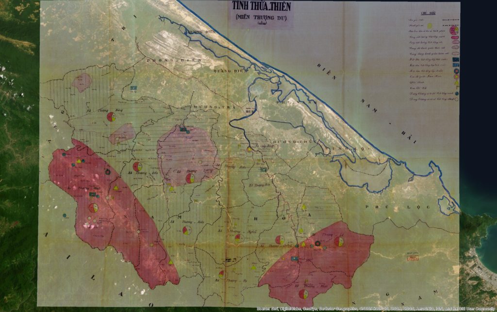
Here’s a link to the full-rez, georeferenced (for ArcGIS) FILE. Source info: File 17331, Record Group ĐICH, Vietnam National Archives Center No. 2.
Before I go further, let me just apologize outright to my geographer and GIS friends for providing no metadata on this. Please sympathize, I’m not an agency supplying data but an historian offering up usable files for the few.
Now, what’s cool about this map, especially when overlaying current satellite imagery, is how what was once a jungle clearing, bull-dozed grids of housing blocks and “enemy bases” has grown in the postwar era into a full-fledged town and district called Nam Đồng!
This illustrates a very important point about the communist nation-building effort, that not only were they establishing key strategic nodes in highland areas, but they were continuing a centuries-old program of “cultivating” these highland spaces. This term (giao hóa) suggests a particularly Vietnamese (and Chinese) style of interacting with highland groups. Bringing in highlanders to trade, providing literacy (in Vietnamese), integrating them into an expanding – topological – network of “the state”.
By contrast, the Diệm government, especially his brother Cẩn’s shadowy government ruling the central region, took a more brutalist approach to these highland areas that communists had been “cultivating” since 1947.
So, enjoy the map! Download the file, play with it, and let me know if it says anything more to you.
More info:
Here’s what I write about this map and how it fit into RVN nation-building in 1960, from Footprints of War, pp. 124-5:
“The new military rulers in the uplands of the province introduced new political maps with light and dark pink shadings that conveyed their singular purpose of counterinsurgency. Dark pink described areas that were deeply contested while light pink suggested fading support. While such maps fed into national military planning for the RVN, they also informed American military allies who had for years been drawing up similar maps in neighboring Laos and Thailand. The military authors of this map used dark pink shading to indicate areas still largely under the communists’ control. They used a lighter shade of pink to indicate lighter opposition in the hills west of Hoà Mỹ and southwest of another evacuated area, Khê Trái.
As a cartographic projection of the ARVN’s ambitions in 1960 for mopping up these bases of communist support, the map presented communist-controlled regions in symbolic terms most familiar to American counterinsurgency experts at the time. Small pie charts in each highlands commune showed, via darker shaded sections, the approximate percentage of people who were “Việt Cộng in the region,” still a majority across the hills. Lighter pink shading indicated areas with diminished support, and colored or empty circles indicated villages that supported a particular side or had been abandoned, respectively.
Excerpts of the map showing the map’s deep pink areas, the hills around Nam Đồng and the A Sầu Valley, bear closer inspection, for they show how ecological and political boundaries coincided, often separating ARVN posts from communist base areas by only a few kilometers. Reconstituted self-defense units and communist cells, pushed almost to annihilation during several years of unrelenting police sweeps, extended their political and communications networks to the very tips of streams and tributaries on the highest slopes. ARVN troops could not easily penetrate the dense forests without support from Katus and highland groups while communist partisans retained the older practice of navigating by rivers and mountain ridges with help from native highlanders.”
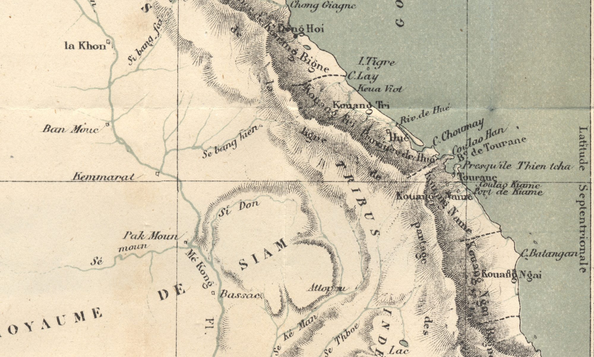
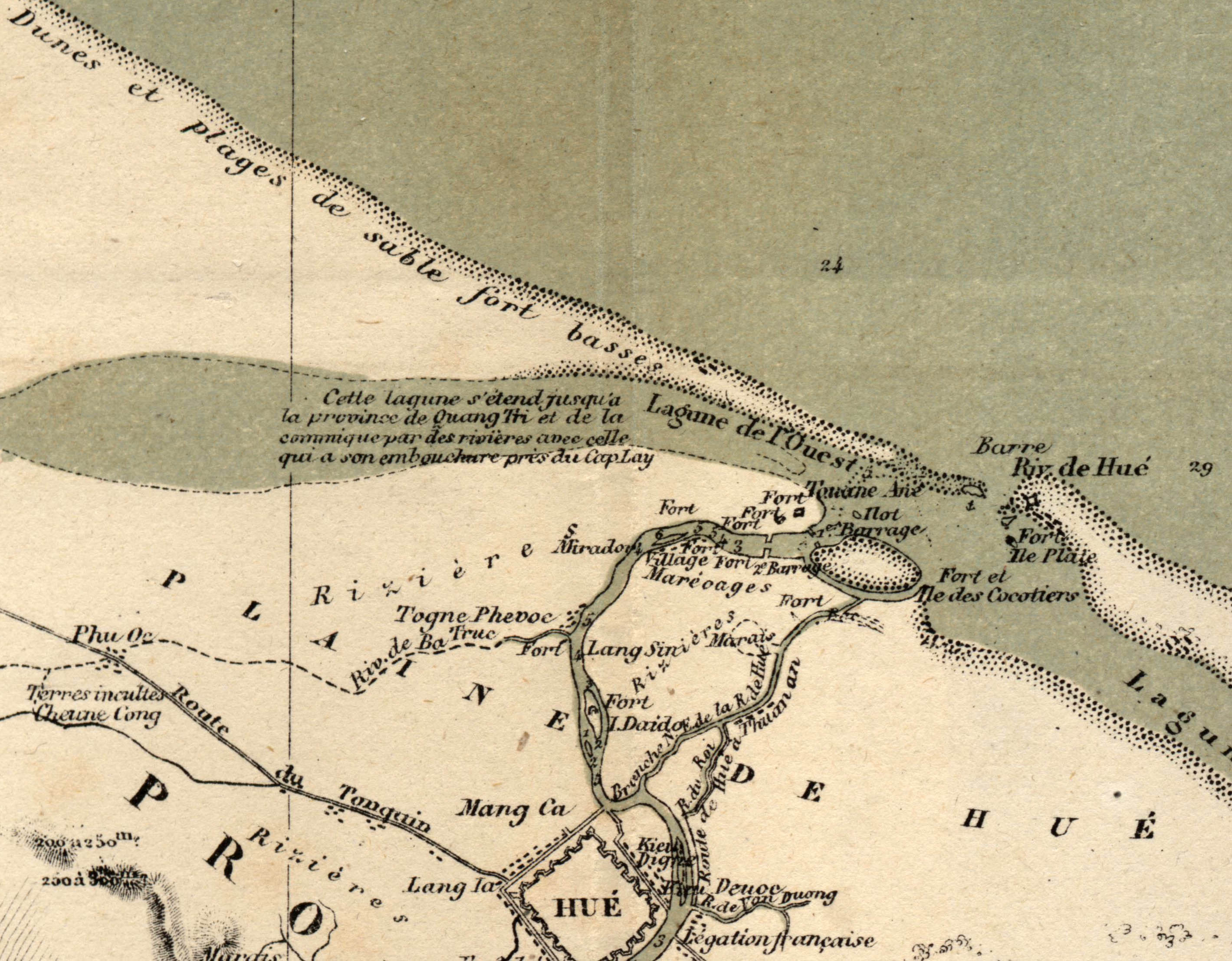
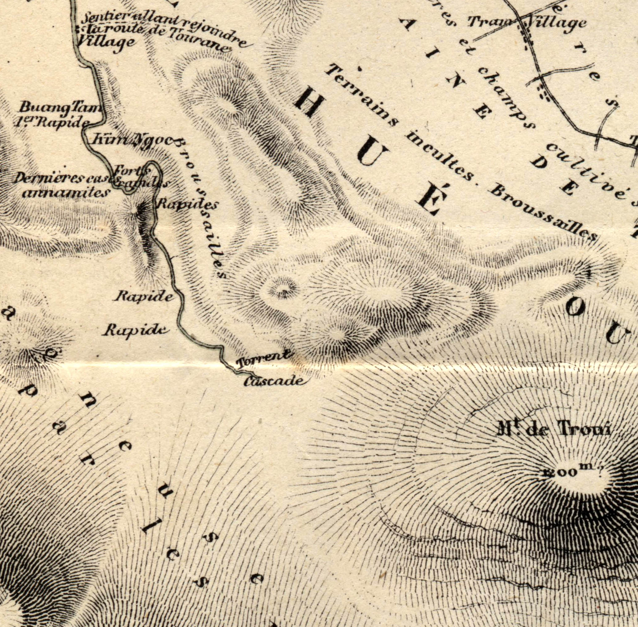
A French Cartographer in Tự Đức’s Kingdom, 1876-77
This first map contribution is one of my all-time favorites for the artistry of the cartographer and the story associated with it. In 1876, the government of the Third Republic made a sort of peace offering with the emperor of Đại Nam (Annam, Vietnam) in Huế, Tự Đức. The offering consisted of three older, slightly out-of-date warships. The official purpose was to help the struggling Vietnamese kingdom re-establish a small fleet since French ships had devastated Vietnamese naval ships in the conquest of Sài Gòn (1862) and the Lower Mekong (1867). The emperor had also given France port space in present-day Đà Nẵng and Hà Nội. So the French government sent three naval captains on a joint military training mission with Vietnamese sailors and officers. Of course, a hidden agenda was to survey the hard-to-access imperial capital, note the defensive landscape and provide any other details that might be helpful should France need, in the future (1883-84 to be exact) to invade. Enter Jules Léon Dutreuil du Rhins, amateur cartographer and troubled naval captain, age 30.

Dutreuil du Rhins was one of a cohort of adventurous, mapmaking Europeans who set out to fulfill his government’s diplomatic and surveillance initiatives while also collecting personal anecdotes sufficient to launch himself through travel books and speaking events as a celebrity adventurer. Like many of his adventurer colleagues, however, Dutreuil du Rhins died young at 48, killed when Golog peoples in southeastern Tibet attacked his survey mission. His last survey mission was published by others, and for the most part his reputation as a cartographer and adventurer faded.
When I encountered his Le royaume d’Annam et Annamites; journal de voyage, (Paris: E. Plon, 1879), I was immediately fascinated by his up-close-and-personal look at life in the beleaguered, war-ravaged imperial capital. The Nguyễn Emperor Minh Mạng had in by the 1830s pretty much banished most Europeans from the capital just as he put the finishing touches on a new Imperial City looking much like the Ming Dynasty city in Beijing. Forty years and several naval battles with France later, the monarchy was eager to get the new vessels and it seemed like maybe there was a possibility for co-existence, at least in the ancient, densely populated Vietnamese coastline stretching from Huế north to Hà Nội.
(Full res version)
When I pulled an original copy of Detreuil du Rhin’s book, I found these two map gems in the back. They represent one of the earliest public maps available to French reading audiences curious about this far-off kingdom that had recently ceded an area the size of France to Emperor Louis Napoleon in 1867. I discuss the survey mission in detail in my book, Footprints of War, (pp. 41-45) because such mapmaking played an outsized role in shaping French colonial ambitions about the potential productivity of these newly claimed lands. As one might expect, adventurers had a tendency to both minimize the challenge of dealing with unruly natives and maximizing the potential for unclaimed, uncultivated lands to yield profits on valuable industrial or export crops.
Writes Dutreuil du Rhins of the people living around Huế:
More than half of the arable land in the province of Hue is still uncultivated, due to different causes that we have already spoken, mainly the laziness of the Annamese [Vietnamese] and their pitiful government. … The Annamite, for whom foreign trade is prohibited, has no interest in the rich crops which would cost him too much fatigue, and it is not encouraged to produce cereals beyond the needs of his consumption because the mandarins, cowardly and crawling with their superiors and as hard and rapacious with their inferiors, they soon despoil his reserves. Le R oyaume d’Annam et les Annamites, 282-3.
If this kind of insulting-yet-purposeful language wasn’t enough, Detreuil du Rhin’s maps visually advanced this point by visually presenting what were deeply eroded, red-clay ravines carving the hills above Huế as gently sloping hills, allegedly still covered in a layer of topsoil, sure to nourish verdant crops of corn, tobacco, or jute. Meanwhile common features in maps of the day such as village names, fields and cemeteries were almost wholly erased. The following excerpt from the Carte de Hue (full-res version) in multiple senses covered over these facts-on-the-ground and for specific purposes. They provided would-be French readers-turned-colonizers an image of a place where they might pursue their fortunes in these greener, gently sloping pastures. Dutreuil du Rhons was, like many adventurer-cartographers of his day, was like a 19th century real estate agent, shaping both the state’s and the public’s ideas of what such far-off places as Annam might be like.
Vietnam: The Chemical War
Next month I’ll be speaking at UNC-Greensboro on October 18th at 7:30pm on the subject of chemicals and the Vietnam War. The talk is part of a year-long series of talks organized to reflect on the 1960s, and I’ll talk about recent research completed as part of my new book Footprints of War: Militarized Landscapes in Vietnam but I’m also hosting a rare film showing from one of Vietnam’s greatest living documentary filmmakers, Trần Văn Thủy. The film we will see is one that received very little attention, “Story from the Corner of a Park” about a war veteran struggling to make a living taking pictures in Hà Nội’s central Lenin Park. Its a wonderful, anachronous piece for two reasons: (1) a growing number of Vietnam War veterans are passing on, leaving only stories and, in some cases, children with illnesses associated to chemical exposures (2) the urban landscapes of Hà Nội have changed so much from this early 2000s film.
For those more familiar with American soldiers’ experiences with the war and especially concerns about Agent Orange, the film is a little-publicized mirror from the Vietnamese side. For details on the pre-talk film showing, please contact Prof. James Anderson at jamie_anderson@uncg.edu.
David Biggs Lecture “Vietnam: the Chemical War”
The talk draws in part from an op-ed in the New York Times that I wrote to address a slightly different issue: the total chemical footprint of the 1960s war extending beyond just the one infamous chemical Agent Orange to include a host of others such as CS, napalm, now-banned insecticides, carcinogenic solvents, and others. I encouraged reader to check out the “readers pick” comments. Here we see not just the range of emotionally and ethically charged responses from readers but many more detailed comments by former chemical platoon helicopter pilots, doctors performing plastic surgery, policymakers and others.
Shortly after the op-ed published, an official from the US Embassy in Cambodia emailed me. He’d read the article and wondered if I knew anything about recent Cambodian claims of buried American chemical waste. I shared my archival data on chemical missions involving CS and even put him in touch with the chemical platoon helicopter pilot who’d commented on the NYTimes site. The US continued the painstakingly long process of decontaminating sites and working with SE Asian governments to remove unexploded ordnance, contaminated soils, and other remains.
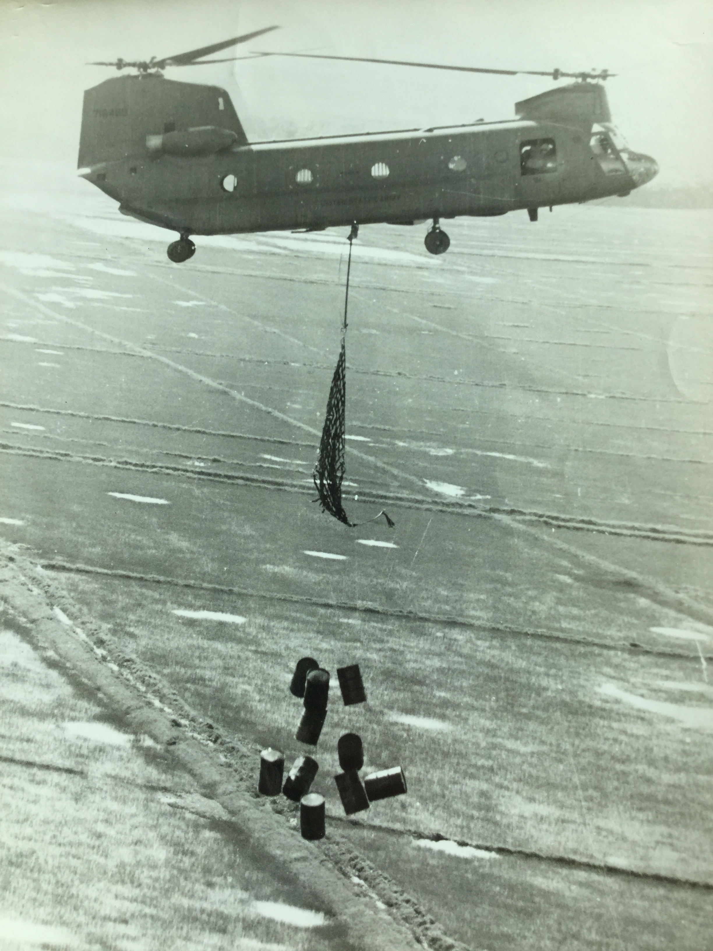
Given the recent discussions about the Syrian government dropping barrel bombs on civilians, I this image from the National Archives shows that they were not the originators of this practice. The image below shows the practice what I think is a “bulk flame drop” – a drop of 55-gallon drums of napalm – per official U.S. Army photographs. “Bulk smoke drops” of CS involved pushing fused barrels out the cargo bay of the CH-47 “Chinook”. Army Chemical Corps soldiers netted the napalm to hang from below since it was a payload of gelled gasoline (!). The barrels dropped a few thousand feet before jet strafing fire ignited them just over the target, often networks of tunnels or bunkers. The aim was to incinerate or asphyxiate enemy combatants (and anyone else) below.